The Western Way

There was a Western I and Western II wooden waggonway.
Both in their time commenced at specially constructed staithes on the eastern shore of the River Derwent. The first way, the Hollinside way, was opened in 1692 and was used for 18 years, but was later subsumed by the Western I, a much grander affair, still visible in places today, which opened in 1712. It ran from the staithes, across the main bank from Whickam to Swalwell, and just beneath the current western edge of Whickam, looking down on and running parallel to the River Derwent. It climbed steadily and merged roughly with the present Fellside Road just before the present entrance to the Golf Club. It snaked through fields until the Pack Horse, at Crookgate. It then ran along through Burnopfield to the productive colliery at the Lintz and Bucksnook. Western II followed the same route initially but found a new path around the northern and western edges, eventually cutting through the golf course and taking a more northerly route through the present day fields to Crookgate. Western II, created both because of ease of route and wayleave problems, opened in 1721 but was virtually abandoned by 1726, only to be used infrequently after that date.
Both in their time commenced at specially constructed staithes on the eastern shore of the River Derwent. The first way, the Hollinside way, was opened in 1692 and was used for 18 years, but was later subsumed by the Western I, a much grander affair, still visible in places today, which opened in 1712. It ran from the staithes, across the main bank from Whickam to Swalwell, and just beneath the current western edge of Whickam, looking down on and running parallel to the River Derwent. It climbed steadily and merged roughly with the present Fellside Road just before the present entrance to the Golf Club. It snaked through fields until the Pack Horse, at Crookgate. It then ran along through Burnopfield to the productive colliery at the Lintz and Bucksnook. Western II followed the same route initially but found a new path around the northern and western edges, eventually cutting through the golf course and taking a more northerly route through the present day fields to Crookgate. Western II, created both because of ease of route and wayleave problems, opened in 1721 but was virtually abandoned by 1726, only to be used infrequently after that date.

There were several large branches added and subtracted to Western I and II.
This area is well blessed with remnants of other waggonways that led down from the prosperous collieries in Pontop and Collierley, notably the Collierley-Leazes of 1722.
This led to the creation of a new route to take the collieries to the Derwent staithes and the Western Way was opened on 24th June 1728 in time for the coal leading season. Western I, much preferred by the waggon drivers, lasted only until 1732 when all production was transferred to this new marvel.
The Busty Bank run remained, throughout the waggonways life, a principal cause for concern and expense and it was rebuilt at least once. This was not for the most part originally the present street of the same name. To lose height the Western Way ran down from Burnopfield past where the existing small horse trough monument now stands, across the road to the present girder footbridge across Bryans Leap Gill, and crossed there to the bottom end of the present Busty Bank by a considerable bridge; there are signs of a bridge of earth over the culvert, similar to the Causey barrage. The way then doubled back across the Gill using the present road and still extant original embankment at the Leap Mill to join the Burnopfield-Rowland Gill road, which it followed down to the Derwent. It crossed the river at Cowford Bridge, but not by the present structure. The waggonway bridge was again a conventional earth battery but built over a single arch over the river. Because of the width of the water this substructure cannot have been low, and it seems to have been wide. The earth embankment raised on top of it may have reached a height of 50 – 60 feet above the river, as the remnants of a battery east of it suggests, making it a rival to the Causey Arch.
- The Bucksmoor Branch, which ran to the Lintz, closed in 1723;
- The Beckley Branch, which exploited Ralph Claverings’ Beckley Colliery, opened in 1725 and ran initially into Western II and eventually down Western Way in 1738. This way still provides a superb walk passing his George and Delight Pits and over a lovely barrage built across the burn and gorge in Beckley Woods. Sadly the pits and way on the other side of the gorge are well ploughed out, although look for the trail of small pieces of coal in the fields and you’ll find them.
- The Bucksnook Way was the most westerly branch, built in 1725 and utilised for 8 years, it snaked along towards the present cricket club at the Lintz.
This area is well blessed with remnants of other waggonways that led down from the prosperous collieries in Pontop and Collierley, notably the Collierley-Leazes of 1722.
This led to the creation of a new route to take the collieries to the Derwent staithes and the Western Way was opened on 24th June 1728 in time for the coal leading season. Western I, much preferred by the waggon drivers, lasted only until 1732 when all production was transferred to this new marvel.
The Busty Bank run remained, throughout the waggonways life, a principal cause for concern and expense and it was rebuilt at least once. This was not for the most part originally the present street of the same name. To lose height the Western Way ran down from Burnopfield past where the existing small horse trough monument now stands, across the road to the present girder footbridge across Bryans Leap Gill, and crossed there to the bottom end of the present Busty Bank by a considerable bridge; there are signs of a bridge of earth over the culvert, similar to the Causey barrage. The way then doubled back across the Gill using the present road and still extant original embankment at the Leap Mill to join the Burnopfield-Rowland Gill road, which it followed down to the Derwent. It crossed the river at Cowford Bridge, but not by the present structure. The waggonway bridge was again a conventional earth battery but built over a single arch over the river. Because of the width of the water this substructure cannot have been low, and it seems to have been wide. The earth embankment raised on top of it may have reached a height of 50 – 60 feet above the river, as the remnants of a battery east of it suggests, making it a rival to the Causey Arch.

The Cowford Bridge over the Derwent at Rowlands Gill, 1750.Notice how on the south side of the river the way splits with the main way bending right in order to lower the gradient. The byway on which the empty chaldrons ran empty takes a steeper track on the line of the modern day road.
The waggonway wright concerned is not known but may well have been William Sanderson, and undoubtedly he would have been the best available, as the principal party in the construction, Lady Clavering, used only the best.
The original vast staithes at Derwenthaugh, second only to Dunston, had a Tyne frontage of 340m and a Derwent frontage of 250m, room for 50 Keel boats at a time and a 6000 ton handling capacity.
The importance was such that the Grand Alliance challenged its validity in Court but lost and in 1728, and 18 years of warfare over a valid western waggonway ended.
The Western Way grew like a tree, in bursts according to the season, pushing out oddly shaped branches, but continually increasing in size so that in length it overshadowed its rival at Tanfield. The reasons for this difference lay in industrial strategy, the search for free drainage, in partnerships and in the topography of the land. The geography offered the long ridge above the Derwent running up to a culminating height, the 1000ft of Pontop Pike, bringing two distinct trunks, parallel to the ridge but on opposite flanks of the Pike.
As early as 1717 George Mallabar had taken Weed Park, half way between Dipton and Collierley and a mile south of Bucksnook, at a time when Western I had no future as a commercial way. At this time his sister, Jane Clavering, was buying up Bryans Leap, leasing Crookgate and sealing off Gibside in readiness for the new Western Way.
This was not done, as has been thought, by simply extending the waggonway that ended at Bucksnook colliery. From upper Lintz there is a well established footpath running south west to Pontop Hall commonly, but mistakenly, thought to be the original Western Way. In fact this is the western branch which ran to Weed Park.

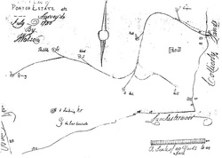
A plan of Collierley Manor, 1820.
Plots 5 to 10 are the Weed Park Estate bought by George Mallabar in 1717. The old waggonway in lower right hand corner is the early Western branch to Collierley Colliery marked old pit. The other old waggonway in the centre of the drawing with the battery to the right are relics of the Western Ways Pont Valley branch which had superseded the Collierley branch.The eastern branch, as shown on a poorly drawn map of 1728, leaves the Western Way at Burnopfield near the old Brewery, and taking a course slowly up the escarpment that overlooks the village, it cuts onto and runs along the present Syke Road and then up to Mountsett running past the Plough Inn of today, and on into Collierley. Further growth of this branch was up through Flinthill and Lily Gardens area.
This was the birth of what was to become the most famous of 18th Century coals grand crus, Windsor and Simpsons Pontop Colliery. In 1728 this partnership had leased coal on land off the southern side of Bucksnook colliery from Meabourne and had extended the waggonway to it. Now they could punch into Collierley and Pontop, in 1739 reaching Pontop. By following the 650ft contour the Way was extended as far as the Spring pit west of Pontop Hall.
The Pontop Estate of 1750. Traced from John Watsons’ View Book.
The Pont Valley extension to the Western Way has been laid as far as the Spring Pit (no. 7). The scale of this plan is remarkably accurate and all of these pits, most of which had 60ft shafts can still be traced. The structure shown middle right is Pontop Hall.
The Pont Valley extension to the Western Way has been laid as far as the Spring Pit (no. 7). The scale of this plan is remarkably accurate and all of these pits, most of which had 60ft shafts can still be traced. The structure shown middle right is Pontop Hall.

Pontop Hall. A nice photograph showing a traction engine pulling a haywain
The first mile is raised and now fenced having been re used as a railway from the Anna pit to the Esther pit of the Lintz colliery, and latterly as a farm road. It continued to Dipton Wood, where it crossed the Dipton Burn on a battery now washed out. A modern replacement with large concrete pipes has met the same fate. In this area the later Dipton ash heap has almost covered the Way. Over the burn, in Weed Park, earlier served at the top of the estate by the Collierley branch of the Way, are two rows of trees, 6m apart, and relics of the old hedges which fenced the ways and provided weather protection for the waggon drivers. At Collierley Lane was a branch visible still, which went a short distance north to an old pit.
At the approach to the Pikewell Burn is another washed out battery, originally replaced by a wooden bridge, now by a more modern concrete structure known locally as the Rustic Bridge. The original stone culvert to the stream can still be seen today.

The Rustic Bridge over the Pikewell BurnFrom the small stream the waggonway builders formed a pond for soaking the waggonwheels with a sloped access on the eastern side. The Way then bends north to Virgins pit and then around on the low side of Pontop Hall before it turns again, following the contours, past Oak pit, along a present day field boundary and joining what is now a well used farm track which runs past abandoned stables. Here it picked up branches leading a little way to Hall pit and immediately behind the stables to Ash pit. It then follows the track along to Wood pit and then Stubble pit before reaching its terminus by 1750 at Spring pit, which again is still visible. The production from this colliery with 9 large pits was enormous at this time exploiting the surface seams, most notably the Hutton seam which was about 60ft down and the seam was averaging 6ft thick.
The way was then extended, in 1755, in a gentle curve to cross the headwaters of the Pont Burn, on a 4m high battery, 10m wide followed by 100m of low battery leading up to East Billingside farmstead. Past the farm, it cuts down and across the contours to the high side of West Billingside farmstead, passing just uphill of the farm buildings, from where it travels for a short distance parallel to but slightly above the farm track that exists today. It merges with the track just below where the later Billingside drifts were opened and then on into Billingside Plantation which covers all the old mines of the Pont Head colliery.
The way was then extended, in 1755, in a gentle curve to cross the headwaters of the Pont Burn, on a 4m high battery, 10m wide followed by 100m of low battery leading up to East Billingside farmstead. Past the farm, it cuts down and across the contours to the high side of West Billingside farmstead, passing just uphill of the farm buildings, from where it travels for a short distance parallel to but slightly above the farm track that exists today. It merges with the track just below where the later Billingside drifts were opened and then on into Billingside Plantation which covers all the old mines of the Pont Head colliery.

A view of Billingside Plantation looking from the west. The diagonal path running down from right to left is the relic of the Western Way. These woods cover the Pont Head Colliery.In 1754 Windsor and Simpson had leased a quarter of Bradley coal and extended their interest into Billingside. The colliery at Pont Head was worked until 1800 when the Pontop coal was transferred to the eastern branch which had been disconnected from the Western Way and joined to Tanfield Way, leaving Pontop coal without staithes at Derwenthaugh.
Thus ended the working life of the greatest of the waggonways, the longest by far, and arguably the most technically difficult. The planning took 18 years of dispute, legal battles and acrimony. The arguments had raged between the most powerful people of their time; the Bowes, Montagues, Claverings, Cotesworth and Liddell.
The coal extracted and led down this Way at one time was over half of all the Tyne coal produced from the Great Northern Coalfield. Seam maps do not show the extent of the Pont Head and Pontop colliery extractions. This is without even considering the Hive pit, on the edge of the Lanchester Common, just over the road from Billingside, which punched deep into Billingside. However, the fact that the Western Way was extended far beyond its economical limit suggests huge quantities extracted from this area. Modern calculations of coal reserves in this area are gross exaggerations.
At nearly 10 miles, this was a true testimony to the ingenuity and fortitude of the waggonway men and the huge leap forward into the true Industrial era that was accomplished on the back of their skills. It must be allowed to remain, to be developed and studied by future generations who can look back at our heritage. It is still there for all its length, just below the surface. If you can’t immediately see it, look for the coal and you aren’t that far away.
